EN
DE


Welcome to the cutting-edge of uphill cycling
and world's most famous ascents of each of the continents
 #passzwang
Welcome to the cutting-edge of uphill cycling
and world's most famous ascents of each of the continents
| Home | |||
| Database | |||
 | World Map | ||
| World's highest cyclable roads | |||
| Overview | |||
| New in 2023 | |||
 | Štulac Sedlo | 1,957m | |
| | Durmitor Sedlo | 1,908m | |
 | Sveti Jure | 1,762m | |
 | Qafa Thores | 1,681m | |
 | Visočica Sedlo | 1,625m | |
 | Galičica Sattel | 1,564m | |
 | Prevalac | 1,560m | |
 | Modré Sedlo | 1,500m | |
| | Vrbatova Bouda | 1,400m | |
| | Qafa Bordolecit | 1,355m | |
| | Krstac | 958m | |
 | Suur Munamägi | 318m | |
 | Gaizinkalns | 312m | |
 | Aukštojas | 294m | |
 | Cap de Formentor | 225m | |
| New in 2022 | |||
 | Zillertal Höhenstr. | 2,015m | |
 | Mt. Olympos | 1,950m | |
 | Juvasshytta | 1,851m | |
 | Monte Zoncolan | 1,750m | |
 | Sliezsky Dom | 1,670m | |
| | Dalsnibba | 1,459m | |
 | Spindlerpass | 1,200m | |
 | Kekestetö | 1,014m | |
 | Flatruet | 975m | |
| | Trollstigen | 866m | |
| | Ørnevegen | 623m | |
| European Alps | |||
| | Theodulpass | 3,332m | |
 | Hohtälli | 3,286m | |
 | Col du Jandri | 3,150m | |
| | Hohsaas | 3,142m | |
| | Madritschjoch | 3,123m | |
| | Rothorn | 3,103m | |
| | Gornergrat | 3,089m | |
| | Gaislachkogel | 3,040m | |
| | Ortlerhaus | 3,025m | |
| | Wurmkogel | 3,023m | |
| | Colle Sommeiller | 3,009m | |
| | Festkogel | 2,898m | |
| | Eisjöchl | 2,895m | |
| | Stubai Glacier | 2,889m | |
| | Ötztal Glacier | 2,822m | |
| | Cime de la Bonette | 2,802m | |
| | Col de l'Iseran | 2,770m | |
| | Viderjoch | 2,763m | |
| | Stilfser Joch | 2,758m | |
| | Kaunertal Glacier | 2,750m | |
| | Colle dell'Agnello | 2,744m | |
| | Col du Chaberton | 2,674m | |
| | Gaviapass | 2,652m | |
| | Col du Galibier | 2,645m | |
| | Colle del Nivolet | 2,612m | |
| | Großglockner | 2,571m | |
| | Timmelsjoch | 2,509m | |
| | Umbrailpass | 2,503m | |
| | Nufenenpass | 2,478m | |
| | Great St. Bernard | 2,473m | |
| | Furkapass | 2,436m | |
| | Hochwurtenspeicher | 2,422m | |
| | Großsee | 2,414m | |
| | Oscheniksee | 2,394m | |
| | Col d'Izoard | 2,360m | |
| | Albulapass | 2,315m | |
| | Uina Gorge | 2,309m | |
| | Julierpass | 2,284m | |
| | Kronplatz | 2,275m | |
| | Sellajoch | 2,240m | |
| | Passo Pordoi | 2,239m | |
| | Passo Giau | 2,236m | |
| | Sustenpass | 2,224m | |
| | Little St. Bernard | 2,188m | |
| | Grimselpass | 2,164m | |
| Rocky Mountains | |||
 | Mount Evans | 4,307m | |
| Hawaii | |||
| | Mauna Kea | 4,200m | |
| Germany | |||
 | Osterfelderkopf | 2,032m | |
| | Nebelhorn | 1,932m | |
| | Alpe Schlappold | 1,740m | |
| | Eagle's Nest | 1,716m | |
| | Roßfeld-Höhenring | 1,540m | |
| | Riedbergpass | 1,420m | |
| | Feldberg | 1,493m | |
| | Fichtelberg | 1,215m | |
| | Brocken | 1,142m | |
| | Salwert | 11m | |
| Other Europe | |||
| | Sniezka | 1,602m | |
 | Klinovec | 1,244m | |
 | Botrange | 694m | |
 | Kneiff | 560m | |
 | Vaalserberg | 323m | |
 | Møllehøj | 171m | |
| Andes | |||
 | Uturuncu | 5,768m | |
| | Chacaltaya | 5,300m | |
| | Salar de Uyuni | 3,650m | |
| | Yungas Death Road | 3,200m | |
| Himalayas | |||
 | Khardung La | 5,602m | |
| | Taglang La | 5,358m | |
| | Potokonkga La | 4,900m | |
| | Namshang La | 4,800m | |
| | Lamayuru Monastery | 3,714m | |
| Ethiopian Highlands | |||
 | Tulluu Dimtuu | 4,377m | |
| Alborz-Range (Iran) | |||
 | Dizinpass | 3,257m | |
| | Emamzadeh Davod | 2,929m | |
| Marathon (European Alps) | |||
| | Ötztal Cycle Marathon | 5,209Hm | |
| | La Marmotte | 5,180Hm | |
| | Maratona Dolomites | 4,190Hm | |
| | Dreiländergiro | 3,546Hm | |
| | Alpenbrevet | 3,643Hm | |
| | Alpen-Challenge | 2,499Hm | |
The way to the fort on top of French Mont Chaberton at an elevation of 3,131 meters used to be the highest unpaved road in the Alps. However, the runway is no longer continuously cyclable for ordinary mountainbikers. Instead you have to push your bike for a long part of the road. In the past this road was used as a military way from the Italian Susa valley up to the French border at Col du Chaberton (2,674m). In present days the runway is left to decline and decay and at an altitude of 2,300 meters the way is almost no longer passable. After pushing your bike up to the Chaberton pass you can likely ride your bike on a 17% slope to the fort on top of Mont Chaberton. But if you look for a constantly rideable runway your are definitely wrong at this place.
Start: Fenils 1,271m
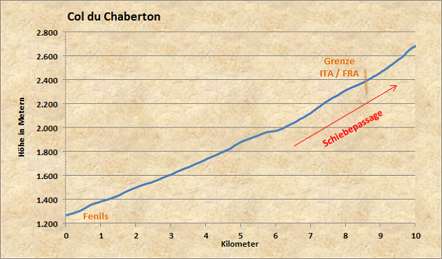
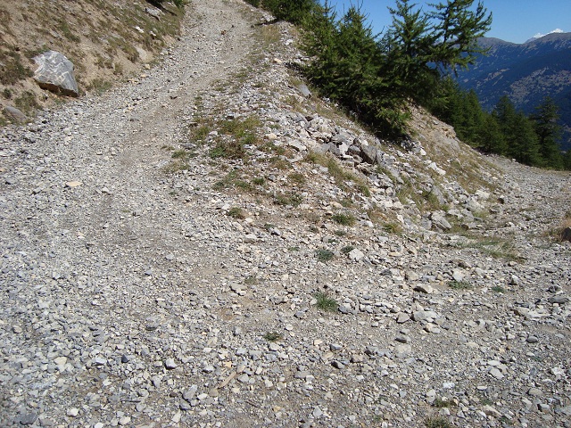
After starting in the Italian village Fenils the way leads with a constant grade of 10% on loose gravel surface to the timberline. After that the route becomes increasingly steeper and stony. This means pushing your bike through the Italian/French border up to Col du Chaberton. This profile ends shortly above pass summit.
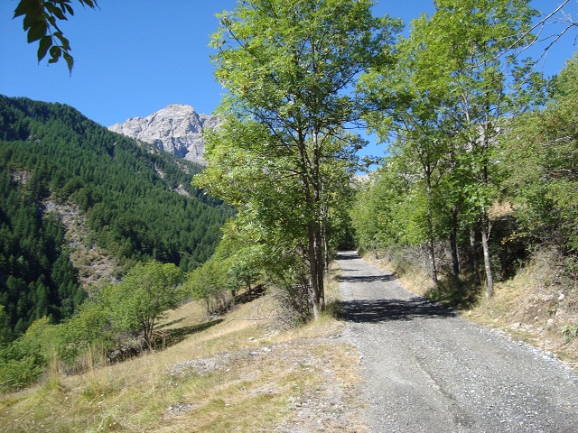
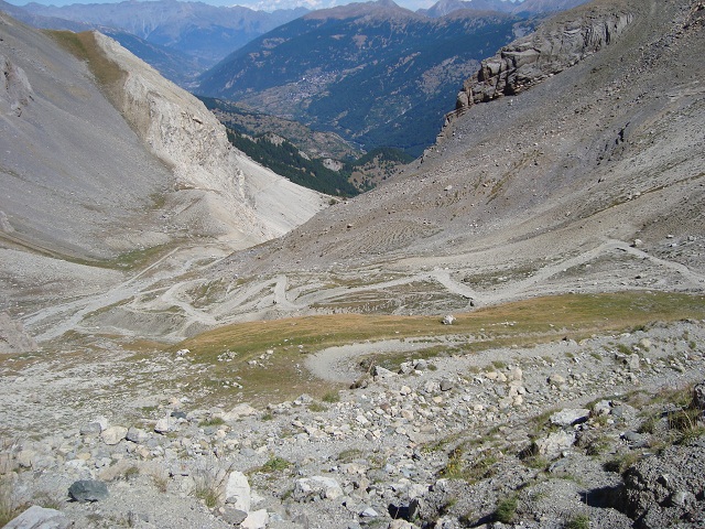
At the beginning of the route you can see the Fort Mont Chaberton in the background (on top of the mountain in the very back). The way winds from the right to the peak of the mountain.
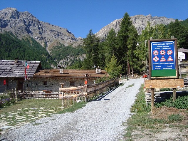
"Strada militare chiuso": At an altitude of almost 1,600m at Loc Pra Claud the way is closed to motorised traffic. But on a bicycle you can proceed your way...
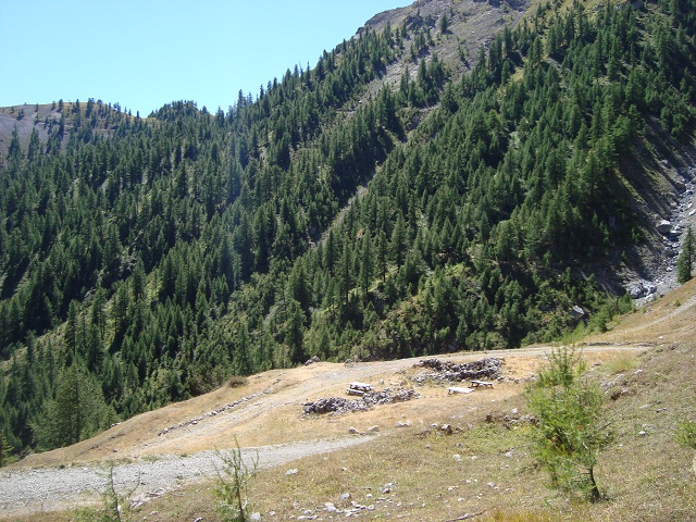
Until this picnic area after some seven kilometers the way is challenging but still cyclable.
After that it becomes very steep and rough gravel encumbers the ride. Only one day after riding the Colle Sommeiller there is, unfortunately, no necessary power today to ride such a way. However, another mountain biker (the only one I meet today) smoothly overtakes me riding a big gear....
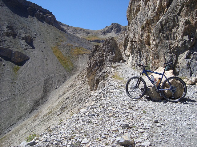
This used to be a road for motorised traffic?! In the background you can see the pass summit of Col du Chaberton. From there the way leads at the left to the peak of the mountain.
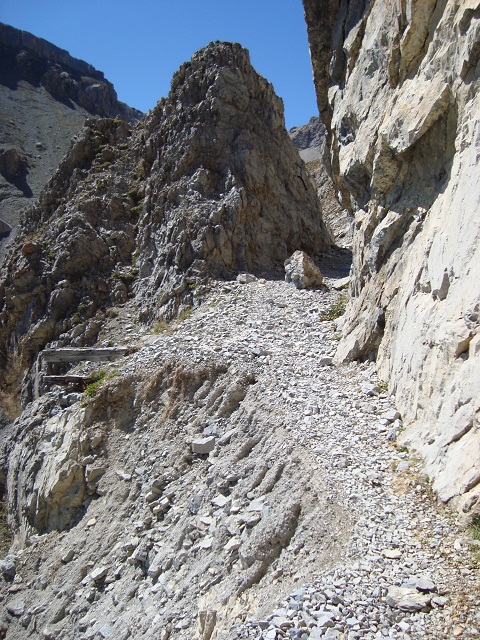
This is definitely the end of the ride. The way has slid down and the runway has a width of only one meter at its narrowest part.
Behind the narrow point there is a high plateau surrounded by 3,000 meters mountains. This is the border to France. Unfortunately, you still have to push your bike for most part of the tour - this has nothing to do with bicycling...
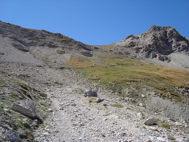
View back down onto the runway which looks cyclable from here (but actually is not).
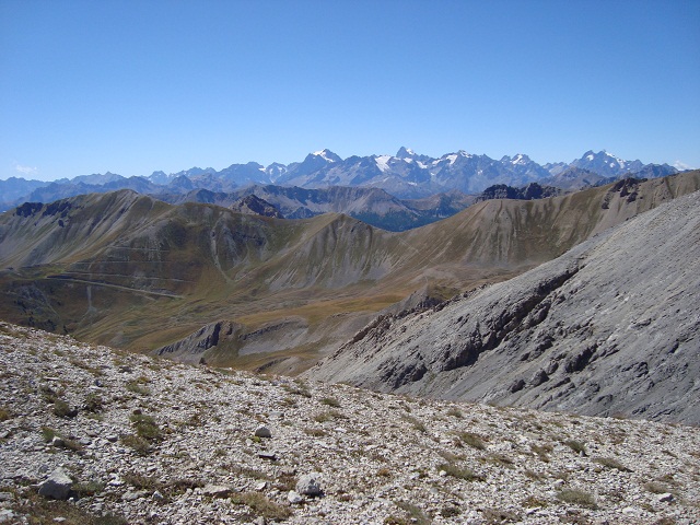
After several kilometers of pushing and carrying your bike you get compensated on pass summit at 2,700 meters by this amazing and breathtaking view to the opposite glaciated Ecrin-Massif (being higher than 4,000 meters).
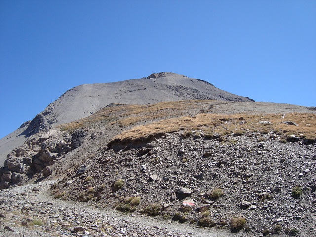
This is the way from the pass summit up to Mont Chaberton. But I am no longer in the mood to ride even higher. Strong gusts of wind make it easy to decide for the return. On the way back you need significant downhill ride skills. Otherwise you might be urged to push your bike also the whole way down. Anyhow, it was quite nice up here!


 #passzwang